Mount Harriet National Park: The Hilltop View Across Port Blair Harbour
Mount Harriet is the hill you see across the water from Port Blair, covered in forest from top to bottom. Most visitors go for one view: the North Bay lighthouse as it appeared on the old ₹20 note. The drive up is cooler than the city, the trails are short and easy, and the whole trip fits into a morning.
In 2021 the government renamed it Mount Manipur, after the Manipuri freedom fighters who were held here in 1891. Locals and drivers still call it Mount Harriet, so either name works.
Updated October 2026 by the Blue Bubble Andaman team in Port Blair
Mount Harriet at a Glance
The hill is on the far side of the harbour from Port Blair, so the route you pick decides how long the trip takes.
Short on time? Take the vehicle ferry from Chatham jetty to Bamboo Flat, drive up to the top, walk to the viewpoint and be back in Port Blair by lunch. Start before 8 am and you will have the view mostly to yourself.
| Official Name | Mount Manipur National Park (formerly Mount Harriet National Park) |
|---|
| Height | About 365 m. Some records give 383 m. It is the highest point in South Andaman. |
|---|
| Distance From Port Blair | About 55 km by road, or about 15 km using the Chatham to Bamboo Flat ferry |
|---|
| Timings | 7:00 am to 5:00 pm |
|---|
| Entry Fee | Small fee at the forest gate. Indians pay much less than foreign visitors, and vehicles and cameras may cost extra. |
|---|
| Time Needed | Half a day including the ferry. A full day if you do the Madhuban trek. |
|---|
| Best For | Views, short forest walks, birdwatching, photography |
|---|
Things to Do at Mount Harriet
We have put these in the order most guests do them: the viewpoint first, then a walk if you have the legs for it.
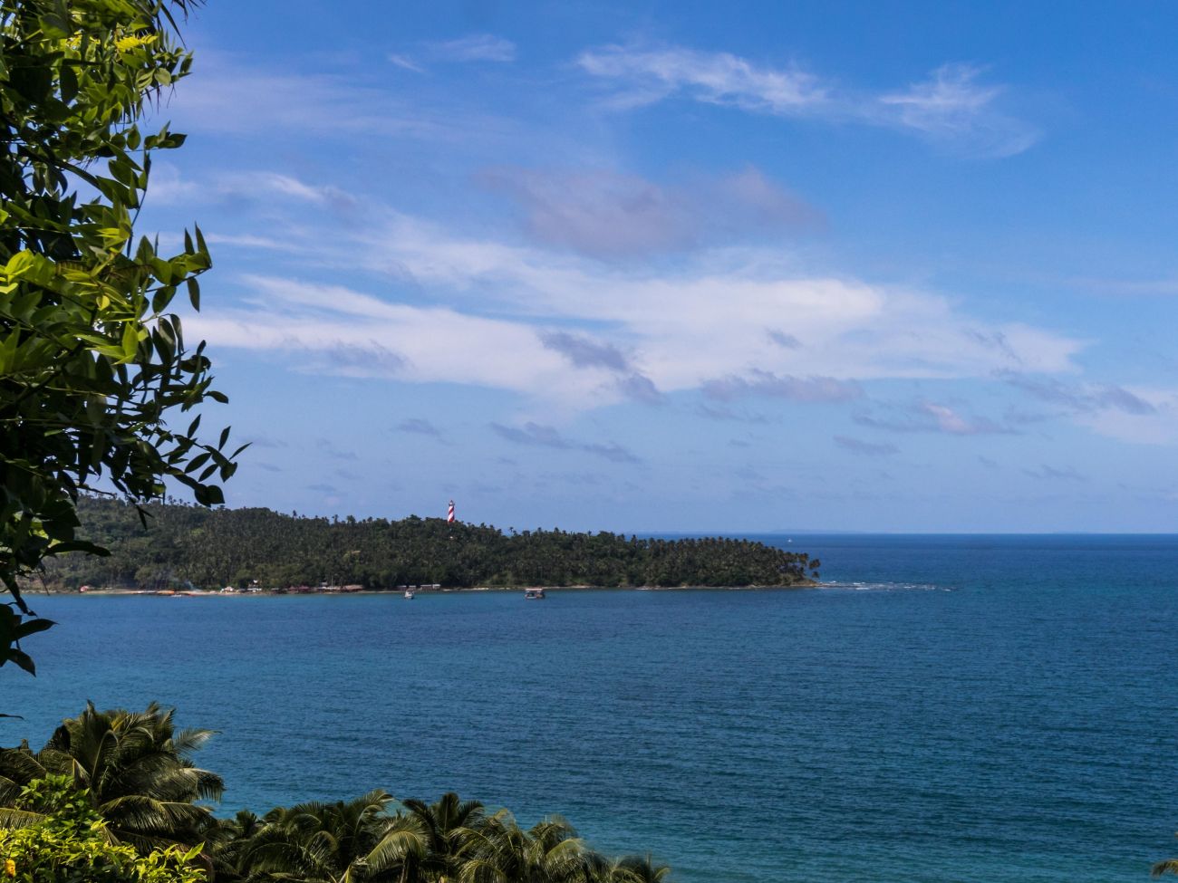 No. 1 · Main View
The Summit Viewpoint and the ₹20 Note View
At the top, a short walk from the parking area · Clearest in the morning
The watchtower near the top looks straight down at North Bay Island and its red-and-white lighthouse. This is the scene printed on the back of the old ₹20 note, and most people bring one along for the photo.
You can also see Ross Island, the harbour and the edge of Port Blair. On a very clear day, islands farther east show up on the horizon. Some drivers know a spot partway down the road that matches the note even better, so ask yours.
 No. 2 · Easy Walk
Kala Pathar Trail
About 2.5 to 3 km one way from the top · Mostly flat · 1 to 1.5 hours return
The easiest walk in the park. The path runs through tall forest along the ridge to Kala Pathar, a group of dark rocks with an open view over the sea.
It is shaded for most of the way, so it is fine for families. Wear proper shoes, since the ground can stay damp long after rain.
 No. 3 · Uphill
Hope Town Nature Trail
About 4 km from Hope Town to the top · Steady climb · 2 hours up
If you would rather walk up than drive, this trail starts near Hope Town, close to the coast below the hill. It climbs through forest most of the way and comes out near the summit.
Start early, carry water and arrange for your car to meet you at the top.
 No. 4 · Full Day
Mount Harriet to Madhuban Trek
About 16 km through the forest · Guide recommended · Fit walkers only
The long trek goes down through the jungle via Kala Pathar to Madhuban, a quiet beach on the coast with the remains of an old elephant training camp. There is no road to Madhuban, so you come back by boat or walk out the way you came.
Do this one with a guide and forest department permission. We can help arrange both.
 History
Old Chief Commissioner's Residence
Near the summit · 15 minutes
During British rule, the Chief Commissioner of the islands spent the summer up here because the air was cooler. Only the foundations and a few walls of the old house are left now, with the forest growing back around them.
The forest guest house nearby is the place to rest and use a washroom before heading down.
 Wildlife
Birdwatching and Butterflies
Best between 7 and 9 am · Bring binoculars
The park is one of the easier places near Port Blair to see forest birds, including several found only in the Andamans. Early mornings are noisy with calls from the canopy.
It is also known for butterflies, especially just after the monsoon. You may spot an Andaman wild pig near the road, and robber crabs live in the park too.
History of Mount Harriet
The hill was named after Harriet Christina Tytler, the wife of a British officer posted in Port Blair. She is better known for her photographs of Delhi's monuments and her account of the 1857 revolt.
In 1891, after the Anglo-Manipur War, Maharaja Kulachandra Singh and a group of Manipuri prisoners were sent to the Andamans. Cellular Jail had not been built yet, so they were held on Mount Harriet. That is why the government renamed the hill Mount Manipur in October 2021.
The forest was protected as a reserve for decades and later made a national park. Today it is looked after by the Andaman and Nicobar Forest Department. For more on the islands' colonial past, see our Cellular Jail guide.
Best Time to Visit Mount Harriet
October to May is the best season. The sky is clearer, so the view across to North Bay is sharper, and the trails are dry. Go early in the morning. The light is softer, the birds are active and the haze usually builds by midday.
From June to September the monsoon brings heavy rain. The drive is still possible, but clouds often hide the view, the trails get slippery and there are leeches in the forest. If you visit in the rains, stick to the summit and skip the long walks.
How to Reach Mount Harriet From Port Blair
By Ferry and Road (Shorter)
Drive to Chatham jetty, about 5 to 6 km from the centre of Port Blair, and take the vehicle ferry across to Bamboo Flat. Ferries run through the day, roughly every half hour, and the crossing is short. Your car comes on board with you. From Bamboo Flat it is about 6 to 7 km up a winding road to the park gate.
By Road (Longer)
The road route goes north around the bay through Ferrargunj and takes about 55 km, a little over an hour each way. It is useful when the ferry queue is long, and the drive through the villages is pleasant.
There is no regular bus to the top, so a private cab for the morning is the simplest option. If you are travelling with us, the ferry, car and gate tickets are all arranged.
Places to Visit Near Mount Harriet
Chatham Saw Mill is right next to the Chatham ferry jetty, so it is easy to see on the way across. North Bay Island, the island you look down on from the summit, is a short boat ride from Aberdeen Jetty and good for snorkelling. Ross Island is usually done on the same boat trip.
For everything else around the city, see our guide to the best beaches and attractions in Port Blair.
Want Mount Harriet built into your Andaman trip?
What are the Mount Harriet timings?
The park is open from 7:00 am to 5:00 pm. Reach by 8 am if you want the viewpoint without the crowds and a clearer view of North Bay.
Is there an entry fee for Mount Harriet?
There is a small entry fee, collected at the forest gate. Foreign visitors pay more than Indian visitors, and there may be a separate charge for vehicles and cameras. Rates change from time to time, so carry some cash.
Why is Mount Harriet now called Mount Manipur?
In October 2021 the Government of India renamed it Mount Manipur to honour the Manipuri freedom fighters who were held here after the Anglo-Manipur War of 1891. Most locals and drivers still use the old name.
How far is Mount Harriet from Port Blair?
By road it is about 55 km around the bay, a little over an hour each way. Taking the vehicle ferry from Chatham jetty to Bamboo Flat cuts the trip to about 15 km in total.
How do I reach Mount Harriet by ferry?
Go to Chatham jetty in Port Blair and take the vehicle ferry to Bamboo Flat. Ferries run roughly every half hour and carry cars as well as passengers. From Bamboo Flat it is about 6 to 7 km by road to the park gate.
Which view on the old ₹20 note can I see from Mount Harriet?
The back of the old ₹20 note shows North Bay Island and its lighthouse, and that scene is the view from Mount Harriet. The watchtower near the top gives you almost the same angle.
How much time do I need for Mount Harriet?
Plan for half a day from Port Blair, including the ferry. That leaves time for the viewpoint and the Kala Pathar walk. The trek to Madhuban needs a full day.
Which trails can I walk at Mount Harriet?
The Kala Pathar trail is about 2.5 to 3 km one way and mostly flat. The Hope Town trail climbs about 4 km to the summit. The longest is the 16 km trek down to Madhuban, which is best done with a guide.
What is the best time to visit Mount Harriet?
October to May, early in the morning. The sky is clearer in these months and the trails are dry. In the monsoon the view is often hidden by cloud and the forest paths get slippery.
Is Mount Harriet suitable for children and older travellers?
The summit is easy, because you can drive almost to the top and the viewpoint is a short walk from the parking area. The Kala Pathar trail is flat enough for most children. The Hope Town climb and the Madhuban trek are better left to fit adults.
What wildlife can I see at Mount Harriet?
Forest birds are the main draw, including several species found only in the Andamans. The park is also known for butterflies, and you may see an Andaman wild pig or a robber crab.
Are there food stalls and washrooms at Mount Harriet?
There is a forest guest house near the summit with basic facilities, but do not count on a proper meal at the top. Eat in Port Blair or Bamboo Flat and carry water and snacks with you.
Can I combine Mount Harriet with other places in one day?
Chatham Saw Mill is right next to the ferry jetty, so it fits in easily on the way. Many of our guests do Mount Harriet in the morning and Cellular Jail or Corbyn's Cove in the afternoon.